Outerra Worlds Forums

Please login or register.

Login with username, password and session length
Advanced search  

News:

SMF - Just Installed!

Show Posts

This section allows you to view all posts made by this member. Note that you can only see posts made in areas you currently have access to.

Messages - Haerangil

Pages: [1]
1
General Discussion / Re: Maps
« on: March 13, 2014, 08:41:55 am »
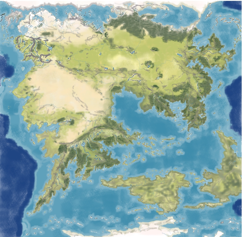
Here's our Globe...

looks nice but is probably quite incorrect from a geographer's point. The Harad looks quite out of shape- I wonder what we did wrong...


http://www.flickr.com/photos/45380944@N05/sets/72157642281483663/


2
General Discussion / Re: Maps
« on: March 11, 2014, 10:40:28 am »
Yes... if those would be the proportions of Middle-Earth it would be a REALLY HUGE continent...

Now one could understand why  Aragorn thought in "the far countries of Rhun and Harad (...) the stars are strange" since the continent reaches far out into the southern and eastern hemisphere...

I had to add all those Mountains because they were part of the original maps Iǜe used... however I think most of them would have been not higher or maybe even smaller than the Evendim Hills.The Orocarni, Ered Engrim, Hithaeglir and Ered Nimrais would be the highest mountain ranges... perhaps with the remnants of the Southern Grey Mountains, Yellow Mountains and Mountains of the wind.Iḿ not sure about the Ered Laranor and Ered Harmal...  The ICE Books state that the Ered Laranor were parts of the eastern Yellow Mountains bent westwards after the great cataclysm and the Ered Harmal formed somehow by the fall of the great Lamp Ringil...  however looking at Tolkien's sketches to me it would seem more likely that the western Arm of the Ered Harmal was a remnant of his southern grey Mountains and it's eastern reaches possibly related to the Highlands on the Isle of Almaren. The Ered Harmal also could rather be a remnant of the Mountains of the Wind, given that Tolkien stated Men awoke in mesopotamia, which would place them and Hildorien more to the center of the continent, roughly the equivalent of the Chy-Lands.
 

I've asked a friend of mine to help me with a globe, but that would be a more simplified map  not that detailed. We'll see...

3
General Discussion / Re: Maps
« on: March 03, 2014, 12:51:04 pm »
Hi there!

I´ve recently tried to reshape pete Fenlons continental map by projecting his map over a real-world    equal-area and isogonic projection https://www.flickr.com/photos/45380944@N05/12812910113/


As you may notice the northern/Forodwaith and barls syrnac parts are based directly on your MEDEM maps

i´ve however still not advanced in creating a real globe.


4
General Discussion / Re: Maps
« on: August 05, 2013, 02:44:26 pm »
Thank you  :)
I counld't adjust Mr. Fenlons maps until I worked with  a globe and maps depicting a round world.

this is real World Siberia:


I see a strong similarity between the Ob estuary and the mouths of the Talathrant, so I interpret the Barents and Kara Sea as the Bay of Utum.The Novaya Zemlya look like one of the Barl Syrnac peninsulas and the coastline of Sharthax and Uab has a striking similarity top the northern siberian coasts.


I drew this map combining both:


on my Globe:


I took the arctic Sea and polar regions as the Iced Realm and frozen sea...  as you can See I#m still not yet finished. I#m working on it and hope to improve it and draw better maps in the near future...

I hope to find a Way to use this reinterpretation of Mr. Fenlons Maps for a new , globed map of southern Middle-earth too...

A flash animation of the Shaping of Arda would be a really cool thing...  but I don't know yet If I can do it...  maybe if I have a better Idea what the utter South looks like...

5
General Discussion / Re: Maps
« on: June 28, 2013, 10:16:02 am »
Thanks a lot! Sadly I'm not at all skilled in 3d Animation so i stuck to pencil and Watercolours or Photoshop drawing so far...

Yes the World of Arda maps... they were kind of tricky... I liked Karen W. Fonstadts Versions but her continent is far too small, the entire planet would be just a quarter of our Earth if they'd be taken literally...  they also contradict Aragorn's statement that he'd travelled south where the stars were different...  which must mean that Middle-Earth stretches far over the equator in the South.

So i took a Gall–Peters projection and tried to fit Tolkien's sketches on it...  the Westlands and Beleriand are thus far smaller in comparison to the entire continent... But actually I'm more pleased with the maps laid upon a real globe... after all Pete Fenlon's maps use several distinct similarities to the real world, his Barl Syrnac and Bay of Utum is obviously derived from the coastal lines of the kara sea and the west siberian lowlands while his northern peninsula seems to be derived from the north siberian lowland and the severnaya zemlya.Also in the east the lands of aegan are quite similar to the bay of okhotsk, the red gulf of aegan is close to the yellow sea and the sea of japan and the Lands of Lôchas D^rus bear a strong resemblance to Vietnam and the Gulf of Thailand.Similarly the Bay of Ormal seems to be based on the Arabian Sea, the Jopi Penisula on India and West-Harad on West-Africa. Only the utter south is more complicated since it's quite far from Tolkien's drawing as well as real-World Black Africa...

6
General Discussion / Re: Maps
« on: June 28, 2013, 06:47:40 am »
I#ve drawn quite a lot of maps in my  time, but they're quite bad in comparison to the ones drawn by Mister Fenlon, Thomas Morwinski or Sampsa Rydman...

most of them are here:
http://www.flickr.com/photos/45380944@N05/sets/

the continental maps are all based on Pete Fenlons original map, but the outlines of his drawings were laid upon real-world map coastlines by me so the proportions are far bigger.I also experimented with a small globe, first I laif Tolkiens shaping of ME maps on a real-world globe, then i altered the coastlines to align them with the ICE maps...
 
it#s not purist, i just tried to find some kind of compromise between the ICE Version and most other Versions that are based on shaping of middle-earth.

One thing i always tried to do with my maps of the westlands was use all information, first Tolkiens and Christopher Tolkiens own maps, the ICE, then Daniel Reeves Decipher maps and finally the Maps from LOTRO, where for example the great woodlands of the Forodwaith I used in my map have their origin.

7
General Discussion / Re: Maps
« on: June 27, 2013, 04:48:23 am »
Thank you,

I think especially your graphics of the Forodwaith and Near-Harad Lands would fit in perfectly!

I´d like to help but I'm not an expert for databases... that's why i chose Wikia, because it's open and free.I've heard thar Mediawiki is pretty good however...

about Merpedia.... well I've done a lot on it but not alone, there are other contributors as well.And after all It's just a tribute to all the original work that has been done by the people from ICE and many others...  I see myself rather as the chronicler than the inventor or explorer.

8
General Discussion / Maps
« on: June 24, 2013, 10:03:21 am »
Hi there!

First of all I#ve joined the Forum because I'm curious about the project and I wanted to ask you for permission to post some of your great graphics on the MERP Wiki (http://merp.wikia.com/wiki/Middle-earth_Role_Playing_Wiki)  They would be a really fantastic addition...

regards
Haerangil

Pages: [1]